The Venetian merchant Marco Polo, while imprisoned by the Genoese in 1298, dictated his travel memories to a fellow prisoner and writer, Rustichello of Pisa. Recalling his 24-year adventure across Asia and the Middle East no doubt provided entertainment and solace during their isolation. Published in 1300, Marco Polo’s travelogue enjoyed enormous popularity both as inspiration for the European age of ‘discovery’ and as a guide for the armchair traveller.
In our own period of isolation, we too are seeking solace and adventure in virtual travel. For many of us, travel is an essential part of our lives, a necessary escape but also a way to fuel our curiosity. So, how do we encounter the world without leaving our homes? On 23 March 2020, British Prime Minister Boris Johnson instituted a nationwide lockdown. Coincidentally the next day, the American author Reif Larsen wrote an article for the New York Times about his virtual adventures. His answer to lockdown was Google Street View travel. Unsurprisingly for the author of a digital book told through Google Street View (Entrances & Exits), Larsen was quick to identify the opportunities for exploration. Longing for his cancelled holiday to Charleston, South Carolina, he writes how he recreated the elements of the trip with his wife and 3-year-old son. Rather than just dropping down in the centre of Charleston, surveying the buildings and calling it a day, Larsen took his family into a local fish bar, walked along the beach and stumbled across a party. What he added to his trip, of course, was the imagination of an author, the narrative of the journey.
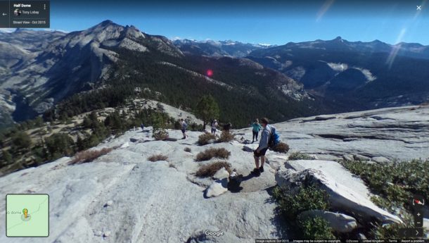
Larsen is not alone in exploiting the benefits of Google Street View (GSV) to see the world. ‘Feast your eyes on these visual treats and be transported’ reads the opener of The Independent’s list for best virtual travel (3 April 2020). Among the places listed are the Grand Canyon and Yosemite National Park, both now closed to the public. Despite their physical closure, a quick trip to Google Maps and you too can be hiking up the infamous Half Dome or standing on the edge of the Canyon. After a few minutes I find myself asking how cold is it, how long did it take to hike to this point, and what does the air smell like? Virtual travel has its limits of course but that doesn’t make the tool at our fingertips any less impressive.
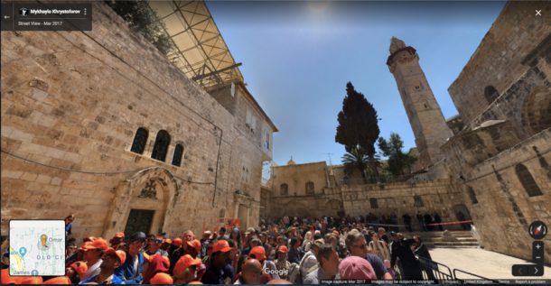
This hugely ambitious project, launched by Google in 2007, now covers 10 million miles of the world’s streets, public parks and the occasional building interior. Initiated by Google’s co-founder, Larry Small, the project first set out to document five US cities at street level. Now Google encourages anyone to add their 360° images, and after thirteen years of documenting the ‘street’ using cars, bikes, and hikers, it is a richly layered archive of the world and its curiosities. This unique lens has inspired artists like Jon Rafman who sees GSV as a cultural text that reflects our curious and changing world. For his project Nine Eyes, launched in 2007 and revived during quarantine, Rafman collates screen shots from GSV that inadvertently capture the strange and the beautiful.
It was the bizarre and the unexpected that made medieval travel accounts so intriguing, too. In a period when only a small proportion of society had the means to leave their country virtual travel was a way to ‘see’ the world. The publishing of Marco Polo’s Travels produced an appetite for tales of voyage. Another great traveller, Ibn Battūta, a merchant from Tangiers, famously wandered across Africa and Asia between 1325 – 54 recording the details of daily life and local customs. His encounter with the Khan Özbeg was one of astonishment: ‘…we saw a vast city on the move with its inhabitants, with mosques and bazaars in it, the smoke of the kitchen rising in the air (for they cook while on the march), and horse drawn wagons transporting the people.’ Not unlike Jon Rafman’s Nine Eyes, it was the curious details of life that stirred the imagination.
In 2020, armchair travel has taken on a new meaning. While modern travel accounts, like Robert Byron’s The Road to Oxiana (1937) or Jack Kerouac’s On the Road (1957), still fuel a sense of adventure, GSV allows us to ‘walk’ the streets ourselves, returning a sense of self determination and happenstance to the journey. Perhaps only now, without the possibility of hopping on a flight, many of us are discovering the joys of virtual travel. After all there is (almost) no limit to where you can go, and no knowing what you might see.
This article was originally written on 20 April 2020
Further reading
- Virtual Travel for These Coronavirus Times — Tour Museums and Stunning Sites Without Leaving Home, Courtney Dabney, Paper City, 17 March 2020
- Virtual Worlds: Can We Travel without Travelling?, Toby Skinner, BBC, 31 March 2020
- Vacated (Justin Blinder), Marta Gutman, MoMA Design and Violence, 21 January 2015
- Classic paintings of world cities meet Google Street View – in pictures, Halley Docherty, The Guardian, 6 March 2014.
Related objects from the collections
Photograph, Kubbet es-Sakhra (Dome of the Rock), Jerusalem, Palestine by K.A.C. Creswell
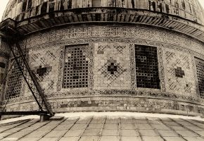
Since its early origins the V&A has collected reference photographs of art and architecture from around the world. In 1920 a set of 2,600 architectural photographs of Islamic architecture were purchased from Sir K.A.C. Creswell (1879 – 1974). Creswell was a pioneer in the scholarship of medieval Islamic architectural history and through his work he systematically documented buildings from across the Islamic world. In this photograph of the Dome of the Rock, a 7th-century Islamic shrine in the Old City of Jerusalem, Creswell captures the detailed mosaic exterior. Photographs, like this one, became a source for designers who were unable to travel to the places they documented.
Print, ‘Air Routes of the World (Night)’, by Langlands & Bell
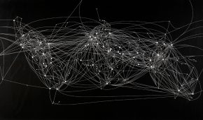
In an age dominated by air travel, Langlands and Bell have redrawn the conventional map of the world based on flight paths. In this alternative view, the airports appear as dots and the lines between them show the routes taken by planes. The effect is similar to star constellations in the night sky. With large parts of the world now in lockdown and 90% of flights grounded in the UK, the pattern of this map speaks to a time of global adventure and escape.
Etching, Le Vedute di Roma (The Views of Rome), by Giovanni Battista Piranesi
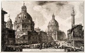
The German statesman and writer, Johann Wolfgang van Goethe, among many others, first experienced the city of Rome through etchings made by the printmaker, Giovanni Battista Piranesi. In his most famous work, Le Vedute di Roma, Piranesi captured the city’s ancient ruins, streetscapes, and churches. In this view he records two Renaissance churches alongside Trajan’s Column. Detailed images like this were the perfect souvenir for Grand Tourists visiting the city. Other etchings in the series are less faithful to real life and include fantastical recreations. Much like memories of travel and adventure, Piranesi combined the real and the imaginary.


Fascinating – an interesting and timely piece. I look forward to more posts like this.