MAP Laboratory, Centre National de la Recherche Scientifique, is a Network Partner in Architectural models in context: creativity, skill and spectacle, an AHRC-funded research network hosted at the V&A.
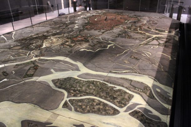
The French collection of Town Scale Models – or plans-reliefs in French – constitutes a precious testimony of the history of France. The scale models of fortified towns were designed for the most part in the 18th and 19th centuries for military purposes. The collection is composed of more than one hundred scale models at 1/600, which can reach several tens of square meters. Many cities would like to exhibit and utilize these scale models. Unfortunately, most of the scale models are stored in containers, and remain unexploited due to their fragility, their dimensions and the requisite conditions for their conservation. The aim of the URBANIA project is the valorisation and the diffusion of digital models through the creation of virtual models.
This project – financed by the French National Research Agency (ANR) – involves two laboratories from the French National Center for Scientific Research (MAP School of Architecture of Nancy and ICube in INSA Strasbourg) and engineering companies (INGEO and ArxIT). The aim of this project is to define the process from the acquisition stage, to the 3D reconstruction and the semantic enrichment of town scale models, in order to create georeferenced semantically-enriched 3D models.
The case study used for this project was the town scale model of Strasbourg, exhibited in the Historical Museum of Strasbourg. This scale model was built from 1725 to 1728 and provides historical information about the city of Strasbourg in the 18th century.
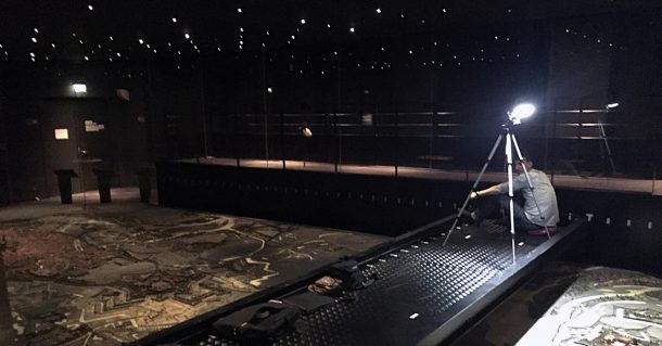
The photogrammetric recording of the physical object was challenging: a mobile platform was installed to perform the acquisition without removing the glass partitions. It is important to take into consideration the scale model’s shape for the acquisition process. This dedicated platform was used to capture the space representing the street between buildings. Over 4000 photographs were taken for obtaining a sufficiently dense point-cloud.
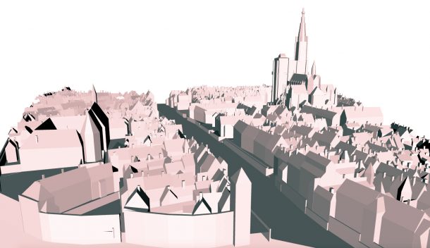
In order to perform the 3D parametric modelling of the city, the point-cloud of the scale model was first segmented into building blocks. Then, for each building block, the roof points were identified and the roof elements were extracted (chimneys, roof ridges and roof planes). The 3D parametric modelling of building blocks was carried out, using roof polygons as input.
Finally, the virtual model was created and enriched thanks to historic and iconographic elements. All the monuments, roads, bridges and important squares will be documented by experts, and this information will be available by clicking on the model. The different architectural elements of a building can be described separately.
This virtual model will be integrated into a Geographic Information System (GIS) to allow different usage scenarios. General public in the museum will be able to use the virtual model to explore the scale model. The virtual model may also be used for urbanistic analysis by technicians (urbanists, specialists of town scale models…) as a reference document when building or when demolition permits are requested. For both usage scenarios, the superimposition of the virtual model onto the actual 3D model of the city from the 18th century will be possible thanks to augmented reality, to compare the evolutions of the city of Strasbourg.
Chevrier, C., Grussenmeyer, P., Halin, G., Landes, T., Macher, H., 2017. Photogrammetric Recording and Reconstruction of TownScale Models – The Case of the Plan-Relief of Strasbourg. Presented at the CIPA, Ottawa, Canada.
To find out more about the network visit our project page.